


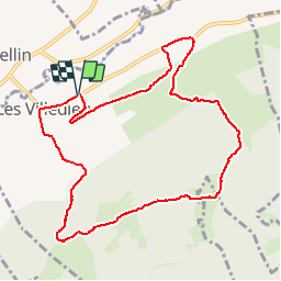
Circuit des Chalets

micheldutilleul
User

Length
10.1 km

Max alt
1179 m

Uphill gradient
332 m
Km-Effort
14.5 km

Min alt
923 m

Downhill gradient
331 m
Boucle
Yes
Creation date :
2016-03-30 00:00:00.0
Updated on :
2016-03-30 00:00:00.0
3h03
Difficulty : Medium

FREE GPS app for hiking
 SityTrail
IGN / Geographical institutes
SityTrail Plus
The world is yours!
About
Trail Walking of 10.1 km to be discovered at Bourgogne-Franche-Comté, Doubs, Les Villedieu. This trail is proposed by micheldutilleul.
Description
Val de Mouthe. Départ de Villedieu-les-Mouthe. Découverte de 5 chalets d'alpage. (Randonée 14 www.otmouthe.com)
Positioning
Country:
France
Region :
Bourgogne-Franche-Comté
Department/Province :
Doubs
Municipality :
Les Villedieu
Location:
Unknown
Start:(Dec)
Start:(UTM)
289799 ; 5178771 (32T) N.
Comments